View in Browser
California Local Logo
Graphic which spells out The Newsletter.


By Sharan Street
Published May 16, 2022

Image credit: SevenMaps   Shuttterstock.com

5-16-22: Mapping Civic Engagement

According to the Encyclopaedia Britannica, the oldest documented example of journalism was in ancient Rome. Said to date from before 59 BCE, the Acta Diurnal chronicled important daily events—some official (court news, government decrees) and partly private (notices of births, marriages, and deaths). As with journalism for the next few millennia, these communiques bound the society together by sharing information. But a more ancient way of sharing information was through the creation of maps—the earliest of which have been found in cave paintings, showing the location of hunting and fishing territories.

Maps are a significant component of the California Local website. Our Santa Cruz County Traffic & Transportation map shows congestion areas, real-time updated traffic cameras, and lane closure reports. And just launching this week are six new maps showing such amenities as public restrooms, dog parks, other open spaces, birding spots and the Santa Cruz Rail Trail.

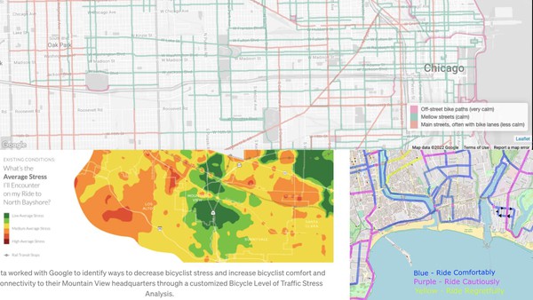
The most significant of these, however, is a map of bicycle routes created in collaboration with members of the cycling community. California Local co-founder Chris Neklason, who built the maps, sees this collaboration as a fundamental part of community journalism. In a blog post titled “How Community Journalism Works Online,” Neklason writes that California Local’s methods of “providing an account of the community” will include members of the community “participating in the making and shaping of the account.”

Launched just a few days ago—auspiciously during Bicycle Safety Month—the Santa Cruz County bike map is the type of interaction that embodies this participation. The map is live now, but that’s only the beginning. We invite local cyclists to join the discussion and share their knowledge.


Working Alone and Together

Cycling is a fun and health-inducing activity, and those are great motivators. Many bike commuters have an even better reason to pedal their way to work, home, the beach, and the farmers market—by getting out of their cars, they are avoiding using the single biggest source of greenhouse gas emmissions.

And yet, most of us know that while individual actions such as this are crucial, we need big collective efforts if we are going to keep our planet from burning up. This week, the California Air Resources Board did just that when it released its bold plan to wean our state from its fossil fuel addiction. Find out more below.

You might also enjoy a couple more blog posts by our friend Chris—one of which explains his reasonable obsession with traffic telemetry. The other is the deepest dive extent into what California Local is, how it works, and why we are doing what we’re doing.


Accurate Traffic Information Is Vital

It’s good to know traffic and weather conditions before you hit the road.
We take a look under the hood of California Local’s Traffic and Transportation portal, which provides comprehensive information on local road and traffic conditions, current CHP incidents and traffic congestion hot spots.

How Community Journalism Works Online

Photo of Babbage Analytical Engine Plan from 1840 at the Computer History Museum
In which we explore how we do community journalism at California Local.

Building a Better Bike Map

Different representations of traffic stress.
Recent discussions in social media revealed a lack of maps of safe local bike routes. So we connected with local bike experts to start a crowdsourced project to create some.