California has a wealth of natural resources managed by the feds, the state, and nonprofit organizations
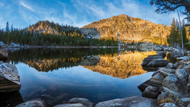
Frog Lake was saved for future generations in 2020 when the Truckee Donner Land Trust teamed up with two partners—Trust for Public Land and The Nature Conservancy—to purchase the Sierra Nevada property from the Smith family. Bill Stevenson Truckee Donner Land Trust
When it comes to open space, Californians are lucky. Some 45 percent of the state’s 100,206,720 acres of land is owned by the federal government, and part of that expanse is available for our recreational pleasure. Plus, there is California’s robust state park system. Not enough room to roam? There are also county and city parks, as well as open space preserved by nonprofit land trusts.
This land is our land—and it’s more precious than ever. According to the Land Trust Alliance, “Every 30 seconds, we lose a football field of natural land to unplanned development.”
So, where can you find your own slice of paradise? The websites below provide direction.
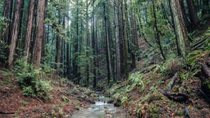
Though not all of the acreage saved by land trusts is open to the public, much of it is accessible to hikers, birders and other low-impact recreational users.
Center for Natural Lands manages preserves that shelter threatened or endangered species and protect sensitive habitat. Use the “public access” filter to find 19 properties.
Land Trust Alliance lists more than 900 member land trusts; use the filters to find organizations in California that offer public access.
Midpeninsula Regional Open Space District, a special district created in 1972, has preserved stunning landscapes in the Santa Cruz Mountains, stretching across San Mateo, Santa Clara and Santa Cruz counties.
The Nature Conservancy, founded in 1951 and active around the globe, also has preserves in the Golden State. Explore them online first, and then get the lowdown on how to visit.
Santa Clara Valley Open Space Authority, a special district that has protected 30,000 acres since 1993, manages four public open space preserves with connections to the Bay Area Ridge Trail. Its newest preserve bears the name Máyyan ‘Ooyákma, which means “Coyote Ridge” in the Chochenyo language of the Muwekma Ohlone Tribe.
Save the Redwoods, an organization founded in 1917 to protect California’s ancient redwoods and sequoias, manages a site that helps find recreational opportunities in five regions: the North Coast, San Francisco Bay Area, Central Coast, Southern Coast and the Giant Sequoia region.
Trust for Public Land, a national nonprofit headquartered in San Francisco, has preserved more than 514,415 acres of open land in California. The group’s website offers a map with links to 86 completed projects.
Western Rivers Conservancy provides detailed information about its river preservation projects, including maps that show the types of land surrounding the waterways (private and public, state and national, accessible and closed to the public).
Wildlands Conservancy has posted an interactive map that makes it easy to explore its West Coast Nature Preserve System, with free access for all.
California State Parks cares for Big Basin’s majestic redwoods, the dramatic seascapes of Julia Pfeiffer Burns State Park, the craggy vistas of Anza-Borrego Desert and much more. Find a getaway by name or search by map in your vicinity.
California Department of Fish & Wildlife manages more than 1,100,000 acres of fish and wildlife habitat—plenty of territory to hunt, fish, and commune with the natural world. The CDFW Lands Viewer provides geospatial data about the sites.
Four federal agencies oversee about 95 percent of federal land. The U.S. National Park Service, U.S. Fish and Wildlife Service, and U.S. Bureau of Land Management are within the U.S. Department of the Interior. The U.S. Forest Service is part of the U.S. Department of Agriculture.
U.S. Bureau of Land Management oversees various types of land, including cherished sites such as Carrizo Plain and Ford Ord, scenic and historic trails, wild and scenic rivers, and wilderness and conservation areas—including the oldest in the nation, the King Range National Conservation Area, along the Lost Coast.
U.S. Fish & Wildlife Service offers detailed information on the species protected in 62 different California facilities, as well as advice on how to visit.
U.S. National Park Service encompasses incomparable landscapes—Point Reyes National Seashore, Yosemite National Park—and sites of historical significance, such as Manzanar and Richmond’s “Rosie the Riveter” museum.
U.S. Forest Service has an interactive app (it also works on a web browser) that helps fun-seekers find forests and grasslands suitable for their favored activities, from low-impact pastimes like hiking, birding, and fishing to riding all manner of conveyances, from bicycles to horses to motorized contraptions.
Pacific Crest National Scenic Trail, which runs more than 2,600 miles from the US/Mexico border to the U.S./Canada border, falls under the Forest Service’s domain. But since more information is better, also check out the Pacific Crest Trail Association’s website, which offers many tips on tackling this hardcore adventure.